By Jake Powell for EDRBlog.org

In the fall of 2013, the Utah Department of Agriculture and Food opened a prototype grant created to fund localized natural resource planning efforts. At the time, I worked as a watershed coordinator for the Utah Association of Conservation Districts with specific geographic responsibility for the Upper reaches of the Weber River Watershed. I applied for a small amount of funding from the grant with hopes of working with a group of about 15 ranching families who owned property in the South Fork watershed, a small, sub-watershed of the Weber River drainage. I was elated to be awarded the grant but admittedly, I was naïve to the challenges and opportunities that the planning process would create with my limited experience in formal natural resource planning training. Little did I know that the effort would completely change my perspective and approach to natural resource planning and implementation.
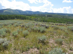
The South Fork watershed sits at the headwaters of the Weber River and contains one of the few remaining strongholds for the native Bonneville Cutthroat Trout. It is a landscape known for producing prized elk and deer that hunters from around the world pay top dollar to hunt. The watershed was highly exploited for its underground oil reserves in the 1970s, and the grassy meadows and uplands have been utilized for sheep and cattle ranching since the first pioneers settled the area. The watershed is entirely privately owned and most of the families trace their ranching heritage back several generations, they are deeply bonded to the land through both economics and tradition.
Get notified when new articles are posted to the EDR blog – sign up for our email list »
I struggled to create an approach that respected the landowners and addressed the environmental challenges the watershed was facing. I observed several planning processes that utilized a team of experts to assess the natural resources of an area, develop recommendations, write a wonderful plan full of countless photos, charts, graphs, and text, and then invite landowners to a public meeting where they work to convince them of the necessity of implementing their recommendations, typically at a significant resource expense to the landowner. I had also observed resistance from the landowners and frustration from the experts and planners, and despite the clarity of the charts and graphs, the landowner’s behavior wasn’t changing and the natural resource situation wasn’t improving.
I wondered if perhaps the document full of words, pictures, and charts (i.e. “the plan”) was not nearly as important as the process that developed the document. I had not received any type of facilitation or collaborative planning training, nor did I know it existed. All I knew was that I wanted to do it differently, and I was going to figure out a way bring those ranchers to the table to plan with them, rather than for them.
I met with each landowner to listen to what they were interested in and let them know that I was going to be working with them to help develop an assessment and vision for the future of the watershed. This exciting announcement was met with varying degrees of excitement ranging from luke-warm acceptance to conspiracy theories about stealing water and private lands. I was inadvertently doing a haphazard situational assessment that proved to be extremely valuable as I began to craft an approach to collaboratively planning.
I learned first that the social landscape was far more complicated and hard to assess than the physical landscape. There were long and complicated stories behind the relationships between each of the families in the watershed that governed the present-day relationships: mistrust, historic offenses that occurred between great grandfathers, alliances through marriage, divisions occurring through divorce, and business deals gone wrong decades in the past. Once I understood these relationships, I noticed the physical manifestations for these relationships on the landscape: parallel roads going to the same spring split by a fence built by feuding brothers, a common gate with dozens of locks because no one trusted each other with a common key.
I also realized that these landowners had an immense amount of local knowledge that I needed to gather, respect, and value along with all of the GIS and scientific information available in the watershed. This realization became a key thread that tied my process together.
I invited all of the landowners to a meeting in the early spring, hoping to catch them before their busy summer season, and focused on the landowners tell me what they wanted to address in the plan and who they knew that could come and teach the group about that particular subject. The group was concerned about many of the subjects I was interested in pursuing and suggested experts that I wasn’t even aware of. I then created a schedule of bi-monthly meetings where subject experts would come and talk to the group about topics ranging from water supply forecasting to forest health and fire mitigation to range improvement for beef production to cooperative big game management. The effort became about creating a shared understanding of the ecological challenges their specific watershed was facing through experts the landowners trusted. The meetings were well attended and the landowners asked questions of both the experts and each other.
One moment I vividly remember was when we discussed the water supply they depended on for irrigation. In addition, the fish and wildlife also depended on this supply for survival, but it was projected to change in the future due to climate change. With concern about the reception of this topic and invited expert, I asked the group to tell me if they had seen a change regarding snowpack. They began to share amazing stories from their childhood about the snow not allowing them access to a certain area of their ranch until a certain date. Now they can access that area much sooner. They told of irrigation needs occurring sooner in the year and lasting longer, range grass species changing, forest health observations and more. Their observations were far more salient than any chart, so the invited expert began to explain the science behind what they had already observed and the implications of these observations into the future. A flicker of trust began to develop in the group as a shared understanding was beginning to develop within the landowners and experts.
At the end of about 9 months of meetings, we prioritized the needs of the watershed and developed shared strategies that addressed the challenges we had all learned more about, making the problem-solving process more collaborative and grounded. The big breakthrough occurred when the landowners realized that the ecological challenges extended beyond property boundaries and proposed solutions needed to be expanded beyond fence lines as well. Once their shared understanding uncovered the reality of their interconnectedness, they were forced to confront some of the social traditions that reinforced fences and property lines. For example, one landowner relied heavily on big game hunting as a source of income. However, he only owned lands that were suitable for summer and fall range for the big game he was building a business around. The critical winter range for his prized big game was all on other lands whose management he did not control. The landowner who did own the winter range had never considered how over-grazing and dense, overgrown pinion-juniper forests on their property was negatively affecting an adjacent landowner. As these mutual needs and resources were uncovered, trading across differences became more collaborative and transparent.
The planning process took nearly a year and a half. The result was a bound document that was more about recording the processes and discoveries than prescribing a new set of rules for the watershed. The document was a common reminder of these discoveries and they no longer needed a meeting to decide if they were going to buy into the “experts” plan or resist it. They had become the experts in the watershed, and they had the power to implement it.
Our last meeting helped to address the social landscape issues that were starting resolve as people began working together. We had a potluck BBQ at the ranch house of one of the landowners. All of the families of the participants were invited and it became perhaps the first of its kind “watershed family reunion.” Kids played together and ranchers sat in the shade discussing cattle prices, irrigation water, and shared stories their grandparents told about the watershed, among many other topics.
I wondered why it all-too-often feels impossible to get people to work together, even when it is in their best interests. That day I realized that I had often approached people as a name and a title, rather than as a person talking to another person. When I abandoned that dogma, it helped me create a process that was about people and process, rather than a document. I learned that the social landscape is perhaps harder to understand, plan for, and manage than the physical landscape, and ultimately, the planning process is about facilitating people to see themselves and each other in a different light; establishing a vision of a better future scenario; creating logical steps to achieve that scenario; and then feeling empowered to take those steps. Creating a process that allows for that kind of planning is far more satisfying than any document I have yet to create.

Jake Powell is an Extension Specialist for Utah State University Department of Landscape Architecture and Environmental Planning. His professional career has focused on uniting communities to their surrounding landscapes through collaborative planning and design efforts. He has worked throughout the intermountain west to envision and implement watershed planning and restoration projects, natural resource conservation projects, recreation infrastructure, and community economic growth opportunities.
Jake’ research and extension efforts focus on analyzing how the design of communities, infrastructure, and sites affect water quality, quantity, and conservation at both the site and watershed scale. Jake is a graduate of the 2019 Environmental Dispute Resolution Short Course.
